
MASTER PLAN: EFFORTS TOWARD SUSTAINABLE LAND USE MVI
By: Matthew Spehlmann - Monteverde Institute
An internship courtesy of the Grace Elizabeth Groner Foundation in conjunction with Lake Forest College.
Abstract
The efficiency of land use on the Monteverde Institute grounds plays a significant role in the overall degree of sustainability of the Monteverde community at large. For this reason, creating a master plan to guide the use of land is of primary concern to Institute land users.
Introduction
Landscape architecture has taken on many definitions over the course of my internship. At its core, my internship has moved from obtaining information about the natural environment surrounding Monteverde, to gathering impressions of the Monteverde Institute from the nearby community, to plotting the infrastructural layout of the Institute grounds. All said and done, the purpose of my internship has been to get the ball rolling, to put it colloquially, in terms of efficient land use on the Institute grounds. The physical manifestation of this goal takes form as a landscape master plan.
The master plan serves as a guide for future projects that deal with land development on the Institute grounds. Essentially, Monteverde´s unique environment, input from the community regarding desired directions of land use on the Institute grounds, and personal analysis gleaned from the creation of an accurate distribution plan have been blended together into an end product that should be phenomenally helpful in coordinating land use projects on Institute grounds. Communication between different users of the Institute property based on an agreed upon representation of the property is a great step towards coordinated land use and, ultimately, efficient land use.
Study Area and Methods
Early in my internship, research on Monteverde´s unique natural environment was crucial in order to gain an appreciation of the land on which the Institute is situated. For instance, Nadkarni and Wheelwright´s (2000) text, Monteverde, provided ample insight into aspects such as climate, vegetation, soil characteristics as well as other elements pertinent to my eventual work regarding low-impact land use in the region. Furthermore, Wolf Guindon´s narrative, Walking with wolf, written by Chornook (2008) gave a story of man´s quest to live off of the land while leaving as light a footprint as possible. Together the two texts served to familiarize me with the atmosphere the Institute operated in: the Institute acts in some ways as a mediator in the struggle to preserve the extraordinary wildlife of the region while catering to a tourist demand that has negative impacts on the very environment that inspires the demand.
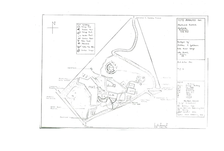
Points of interest at the MVI.
After acquainting myself to the dilemma faced by Monteverde and the surrounding communities, I took up pencil and paper and set out to meet face-to-face with different members of the community. The meetings were unofficial interviews in which I recorded the interviewees´ impressions of the Institute and its land use. Interviewees ranged from staff at the Institute to Quaker practitioners living as far as San Luis. At that point in my internship, I was more of a social architect, as the interviews served to construct a mental image of what the Institute was in the minds of the community.


With an understanding of where the Institute stood in terms of its physical location and with the community´s perception of the Institute in my mind, I began my work on the immediate property of the Institute campus. Armed with a tape measure I sent out among the campus taking note of the triangulated positions of every structure and feature that may be relevant to future projects. The process lasted weeks. Generally, I bounced from the office where I had a developing map draft on a large scale plan to the grounds where I would store measurement notes on a clip board to be transferred back to the office at a later point in time.
Finally, the required measurements were taken and the final step of formalizing the drafts went underway. My supervisor closely guided me along the way as we moved from border design to texturing elements such as gravel roads to adding special interest layers. It is the distribution plan with its special interest layers that provide the bulk of the end products.
Results
The product that has arisen out of my literature study constitutes a small portion of the overall end product. Essentially, I have condensed scientific and social literature down to the most relevant information regarding land use on Institute grounds. This boiling down of information is found in my final presentation PowerPoint. Furthermore, the pertinent information that I felt was necessary in introducing the land use predicament special to Monteverde contains reference pages to sections in texts that elaborate on a finer scale the environmental or social issue to which I refer to in the presentation. The inclusion of reference pages will help future special interest projects cut time on the research stage of their project.
Concerning the interviews, I have compiled many reports of how the Institute is seen by the community. Most of all, the interview reports serve as a checkup on how narrowly the Institute is conforming to its desired goal of being a sustainable voice in the area. The information from the reports has been charted several different ways. The analysis of the reports can be found in the discussion section.
However, the ultimate gift to the Institute resulting from my internship is the distribution plan and its subsequent layers. The distribution plan details the layout of the property, again complete with all elements pertinent to future land use projects. On top of the distribution plan can be placed four special interest layers (more layers can be drafted in order to analyze different aspects of the property that may become of interest when future projects are being considered). However, the four current layers detail access and circulation routes, water ways and flood zones, forest zones, and special features to the Institute that add character to the land while having minimal impact.
These maps will be the first maps that accurately communicate where land use has occurred and potential areas for future land use. Due to this, interns, workers, the community, and any other party interested in the lands on the Institute grounds will share the same understanding of the property on which the Institute is situated. The implications of the final products gain significance upon the review of a trained eye.
Discussion
Upon analysis of the interview reports, I found that the community desires that the Institute serve as a recreation center that emphasizes the nature present in Monteverde. As a recreation center, the Institute would provide the community with a space for activities as well as down-time pursuits such as chatting or reading. Most of the members of the community I spoke with were older and thus recognized that it will be the younger generation who will soon be responsible for staying committed to sustainability. Due to this, members expressed a palpable hope that drawing the community onto the Institute campus will inspire a respect for the land in the youth of the region.
At first glance of the Institute maps, one might simply locate herself according to the other features of the property. Though maps serve to locate and contextualize the user according to her immediate location, the maps and ensuing analysis serve a larger purpose. Efforts towards sustainable land use can be significantly more efficient when users of the land share a common goal for subsequent land use. There have been several projects carried out by single groups of interns only to be neglected when the interns leave the Institute. The land used is then neglected as well and left to future interns to deal with wondering how to convert the land to their specific needs. Instead of having discordant users develop parcels of land for their select interest, an accurate map can serve to coordinate land use over the long run ensuring at the least a consistent use of land.
The Institute is a gem in terms of property value. The difficulty in maintaining the gleam of the gem results from a population of users that sees the land as per select members´ individual, current interests. What belies sustainability is jumbled land use due to failures of carrying out long term visions. I mentioned this master plan was a way of getting the ball rolling in a sustainable direction. Yet, like past projects, the biggest threat to the success of this project is the lack of follow-through by a future intern. The ball may be rolling, but the friction of noncompliance has been a formidable force.
Acknowledgements
Necessary to thank for this opportunity is the Grace Elizabeth Groner Foundation. Without their funding and oversight, this internship opportunity would not have been possible. The Foundation´s association with Lake Forest College enabled my participation in this internship.
Furthermore, the direct supervision of primary coordinators Ashley Gora and Felipe Negrini required hours of time and a bundle of patience in mending my mind from an economic orientation to one of a landscape architect´s. I would like to thank them for their support over the course of my research.
The Monteverde Institute, the community of Santa Elena and nearby towns, and all others who I cannot name person by person deserve my thanks, as they were extremely open and accommodating to the needs of my internship. It was a pleasure to have met those with whom I worked.
References
Chornook, K., & Guindon, W. (2008). Walking with wolf. Canada: Wandering Words Press.
Nadkarni, N., & Wheelwright, N. (2000). Monteverde. New York: Oxford University Press.
Monteverde en Crecimiento - A Growing Monteverde
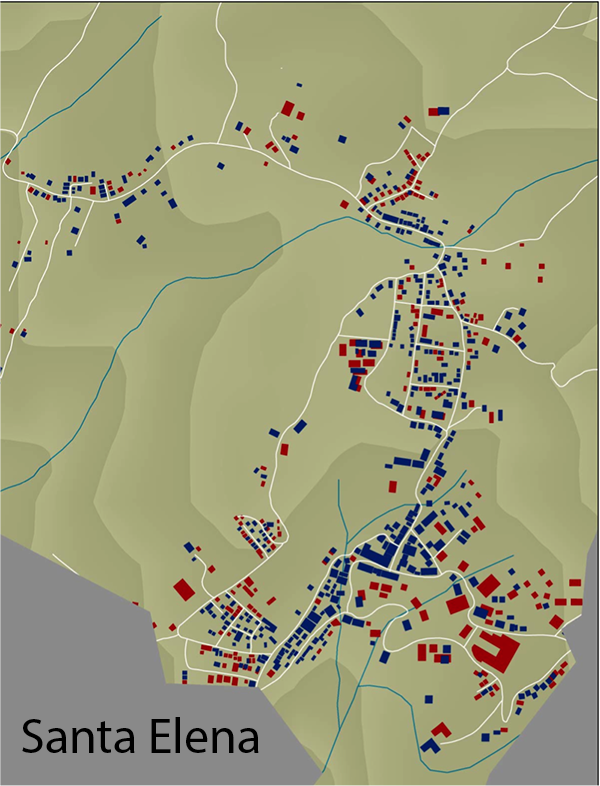
Mapas del crecimiento de edificios en tres zonas del distrito de Monteverde: Los Llanos, Santa Elena y Cerro Plano. Por Samanth Copeland pasante del Instituto Monteverde.
Monteverde en Crecimiento -“Un Proyecto de Mapas”- Reporte de Advances
por: Samantha Copeland--- Equípo: Phebe Myers, Morgan Boyles
-
Monteverde es una región conocida por su biodiversidad, ecología y reservas naturales. Recientemente, la base económica de la zona ha cambiado de la agricultura al ecoturismo. Debido a este cambio la región ha experimentado un crecimiento en la población y el desarrollo. Este proyecto ha contado con la participación de tres personas que han realizado una actualización del desarrollo de infraestructuras. Esta actualización será representada en una serie de mapas que muestran dónde y cómo crecimiento en Monteverde está ocurriendo.
Where tha maps were made in the Monteverde District.
La elaboración del mozaico de comunidades se realizo con la ayuda de la Clinica de Salud de Santa Elena, el Consejo Municipal y el Instituto Monteverde en un proyecto llamado Base de Datos Monteverde, este trabajo se realizo para delimitar comunidades y vecindarios que ayudaran a tener una mejor referencia. Trabajamos en las comunidades de Los Llanos y Santa Elena. Y La mayoria de Cerro Plano y un poco de MV.
Métodos:
Como hicimos los mapas? Caminabamos muchos kilometros en dos semanas y media para un total cuarenta horas totales.
Primero realizamos la recolección de puntos de GPS. Con el uso del GPS recolectamos lineas donde caminamos para actualizar camino y tomamos puntos para actualizar edificios u otros elementos. Entonces: Los puntos son edificios y las lineas representan los caminos. Usamos un GPS para actualización y hicimos un mapa mas exacto. Actualizamos mas de 1200 edificios.
Condiciones Actuales y Cambio durante los últimos 10 años:
Por qué es importante:
- Conocer que cambios están pasando en sus comunidades.
- Decisiones y opiniones sobre crecimiento y inversión de recursos.
- Para planes de emergencias y para personas con necesidades especiales.
- Para el uso de bomberos.
- Impacto ecológico o uso de recurso naturales.
Crecimiento edificios Los Llanos, azul edificios 2003, rojo 2013.
Empezamos con Los Llanos. Es un área de mucho cambio durante los últimos 10 años. Son 248 (doscientos cuarenta y orcho) nuevas estructuras. El tipo de edifico de mayor aumento en los llanos es Residencial.
Los cambios mas grande estan cerca escuela de los llanos, bajo cementerio, y la area norte de la gasolinera.
Densidad comercial es un poco differente. Muchos personas viven en los llanos pero no tienen muchos hoteles y tiendas.
Crecimiento de edificios en Santa Elena, azul edificios 2003, y en rojo 2013.
Santa Elena experimento un aumento de 186 (cien orchenta y seis) nuevos edificios en los ultimos 10 años pero es una histora diferente a los Llanos.
Muchas personas vive cerca la plaza. Pero el aumento de edificios es más comercial.
En el 2003 Santa Elena fue el lugar donde se concentraron los comercios y no es una surpresa.
Lo interesante sobre el cambio es que el centro de Santa Elena experimentó un aumento comercial.
Aumento de edificios en Cerro Plano. Rojo edificios en el 2003, y en azul en el 2013
Cerro Plano tiene crecimento pero menos que Los Llanos y Santa Elena. Solamente 46 edificios mas.
La densidad de los casas es mas alta en la area arriba de Cerro Plano. No hay mucho cambio pero hay mas densidad de casas en los ultimo diez años.
La mayor concentracion en Cerro Plano es de Hoteles y otras atracciones para turistas.
Datos que faltan recolectar:
- La Clínica - Población por comunidad - La Municipalidad - Más datos de Construcción
Más Información:
-¿Cuántos niveles tiene cada edificio? -¿Cuántos cabinas, cuatros o espacios tienen los hoteles? - Mapas de Cañitas, San Luis, Monteverde.
Pueden visitar el fondo de este reportaje para más mapas.
---------------------------------------------------------------------------------------------------------------------------------------
English Summary:
One of the Monteverde Institute Interns, Samantha Copeland helped us create maps that demonstrate the building growth Monteverde has had in three different areas. In blue we can see those that existed in 2003 and in red the ones that existed by 2013. She did this by counting the buildings one by one. For more information on how she did this you can write to us. Thanks to her work we also have an updated map of these areas. In conclusion she found out that Los Llanos has 248 new buildings, Santa Elena 186 and Cerro Plano 46.
Otros mapas- Extra maps:


